English
 Español
 Français
 Deutsch
 Українська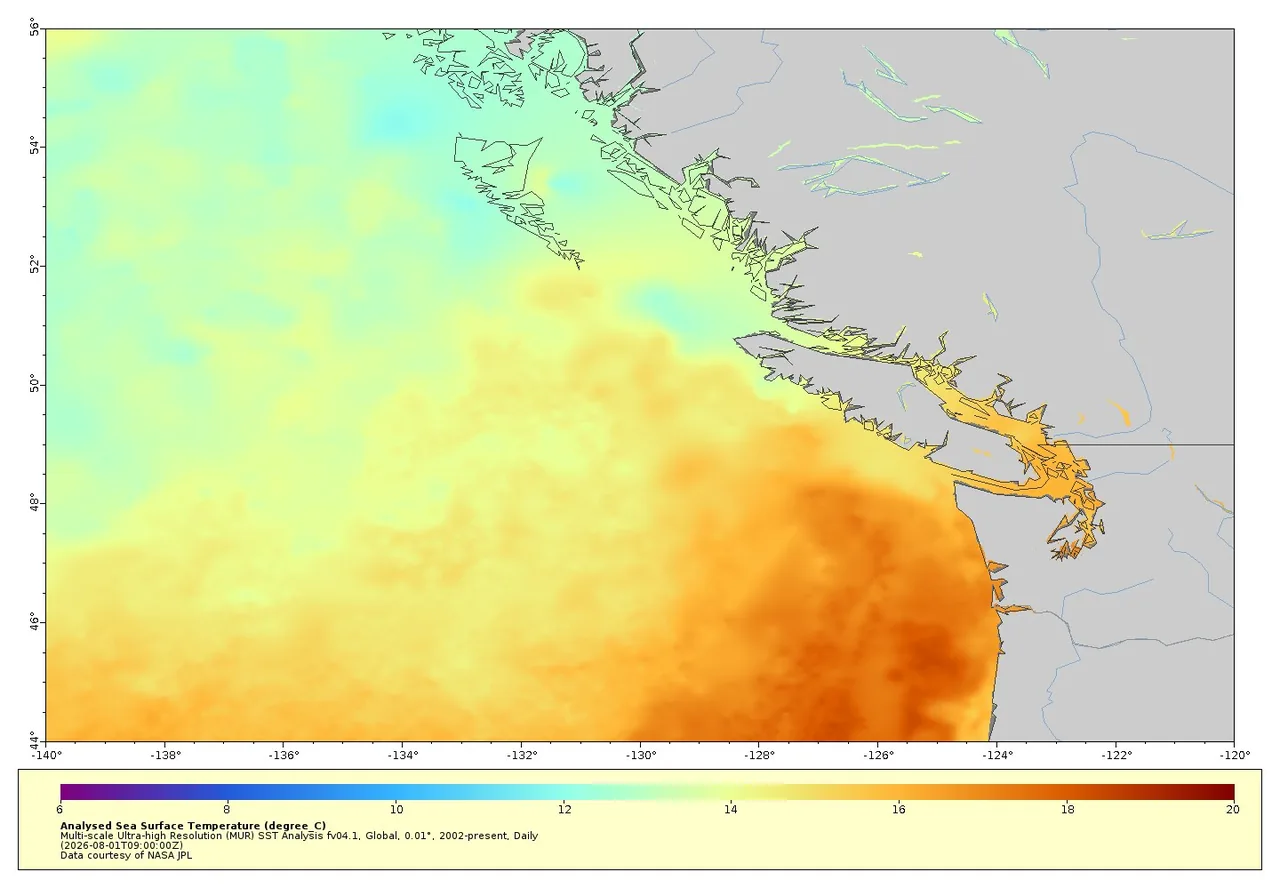
Ocean weather day
- Check marine + city forecast.
- Wind layer even if 'sunny'.
- Open-water plans need cancel flexibility.
- Have indoor backup.
Published 2026-07-13 · FanVancouver Travel Desk
Two questions every summer visitor asks: how hot is it around BC right now, and is the ocean warm enough to swim? This page answers both — a real satellite sea-surface temperature map of the BC coast (above, NASA JPL data, refreshed weekly), live hourly numbers for air and water below, and two interactive forecast maps.
Live: air temperature across BC
Loading live temperatures…
Live: ocean water temperature
Loading sea temperatures…
Live data: Open-Meteo (updated hourly). Colours: blue <10°, teal 10–15°, green 15–20°, orange 20–27°, red 27°+.
Interactive heat map of British Columbia
Live air-temperature layer — drag, zoom, press play for the 7-day forecast:
Interactive ocean temperature map
Live sea-surface temperature layer for the coast and the open Pacific:
Maps: Windy.com. Satellite SST snapshot above: NASA JPL MUR analysis via NOAA CoastWatch.
Typical ocean temperatures by month
| Months | Georgia Strait beaches (Vancouver) | Open Pacific (Tofino) | Notes |
|---|---|---|---|
| January–March | 7–9 °C | 6–8 °C | Wetsuit territory everywhere; Tofino surfing runs all winter (5/4 mm suits) |
| April–May | 9–12 °C | 8–10 °C | Lakes still cold; first brave dips at White Rock |
| June | 13–16 °C | 10–12 °C | Shallow bays (Spanish Banks at low tide) warm fastest |
| July–August | 16–21 °C | 12–14 °C | Peak: English Bay/Kits ~18–20 °C; White Rock & Boundary Bay warmest (21 °C+); Tofino stays cool |
| September | 15–17 °C | 12–13 °C | Still swimmable in calm weather |
| October–December | 9–13 °C | 9–11 °C | Back to wetsuits |
Where the water is warmest
- Boundary Bay & White Rock — huge shallow tidal flats; on a July afternoon after low tide the water hits 21–23 °C, the warmest salt water in the region.
- Cultus Lake, Alouette Lake, Sasamat Lake — lakes beat the ocean: 20–24 °C in mid-summer. Sasamat (Belcarra) is famously the warmest near the city.
- Kitsilano Pool — a 137 m heated outdoor saltwater pool right on the beach (open May–Sep, adult ~C$7), when the ocean itself feels too cold.
- Okanagan (Kelowna/Osoyoos) — 4 h drive: Osoyoos Lake is Canada's warmest lake, 24 °C+ in July–August, and the air is regularly 10 °C hotter than Vancouver (watch the live widget above).
Reading BC summer weather
- Vancouver summers are mild (22–28 °C) but the Interior (Kamloops, Osoyoos, Lytton) regularly hits 35–40 °C — plan Interior road-trip driving for mornings during heat waves.
- Heat warnings and forecasts: weather.gc.ca (Environment Canada). Wildfire smoke forecasts in late summer: firesmoke.ca.
- Water safety: BC ocean beaches have lifeguards only mid-June to Labour Day (Vancouver city beaches); rip currents are a real hazard on Tofino's open-Pacific beaches — swim near lifeguards at Long Beach.
← Explore BC hub — all guides · Vancouver city guide
Why the water stays cold when the air is warm
British Columbia's ocean does not behave like its air. Cold water rises along the outer coast as prevailing summer winds push surface water offshore — upwelling — so the open Pacific at Tofino stays in the low teens through August no matter how warm the beach is. That is why surfers here wear full wetsuits in July.
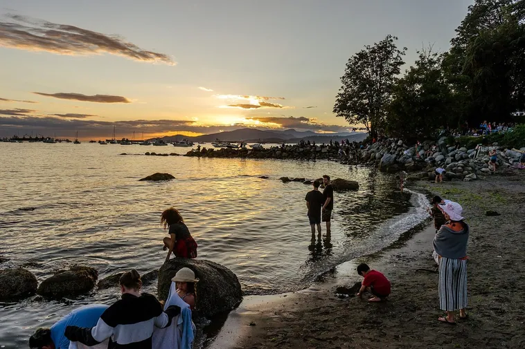
The Salish Sea inside Vancouver Island behaves differently. Shallower, more enclosed and fed by summer sun rather than open ocean, it warms several degrees higher: the Strait of Georgia beaches, Sechelt, Parksville and the Gulf Islands are the warmest salt water in the province by August. Vancouver's own beaches sit in between — English Bay is swimmable for most people in late July and August and bracing the rest of the year.
Where to actually swim
- Warmest salt water: the sheltered east-coast beaches of Vancouver Island and the Sunshine Coast in late July and August.
- Warmest water overall: the Okanagan lakes. Osoyoos is the warmest freshwater lake in Canada and runs far above anything on the coast.
- City swimming: Kitsilano and English Bay in August, or the outdoor pools at Kits and Second Beach when the sea is too cold for comfort.
- Cold-water reality check: anywhere on the open west coast, any month. A wetsuit is equipment, not preference.
Reading the numbers above
A single reading is a snapshot of one buoy at one depth. Wind matters more than the number: two days of northwesterly wind can drop a beach's water temperature several degrees by pushing warm surface water offshore, and a still, hot week can lift it back. If you are planning a swim rather than a paddle, look at the trend across a few days rather than today's figure.
📬 Vancouver This Weekend
One short email every Friday: the weekend's best events, free things to do, and one local tip. No spam, unsubscribe anytime.
How to read this weather / ocean widget
Use heat and ocean temperature as planning context for beaches and ferries — not as a marine forecast for vessels. For warnings, treat Environment Canada and official marine forecasts as authoritative.
- Hot inland ≠ warm ocean; English Bay stays chilly even in heat waves.
- Wildfire smoke can make “sunny” days unhealthy — check air quality.
- Pair with Vancouver Today and rain status.